The repeated collapse of the ice dam holding back Glacial Lake Missoula, at the end of the last Ice Age, unleashed floods that were utterly disproportionate to the scale of the landscape, in the depth and speed of the water. (It’s been suggested it’s analogous to dumping a bucket of water onto a tabletop model.) The floods carved the Channeled Scablands of eastern Washington, including the Grand Coulee. Dry Falls, which separates the upper and lower Grand Coulee, is a nick point where the floods were eroding upstream; the falls’ current position is where the water ran out.
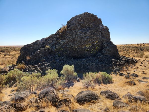
The floods were capable of mobilizing much larger chunks of rock than a typical flood. As the floods exited the coulee into the flat of Quincy Basin and slowed, near where Soap Lake now sits, large boulders torn out by the erosive power of the water began to settle out. This enormous chunk of basalt (measuring 18 x 11 x 8 meters or roughly 59 x 36 x 26 feet, and weighing about 4,350 tons) is the most extraordinary example. Its composition indicates it was ripped out of the coulee walls upstream. Sometimes very large rocks can be transported through being embedded in ice, but the Monster Rock is unlikely to be such a glacial floatstone because glacial ice was not present in the coulee.
A depression downstream from the Monster Rock seems to result from scour as the waning floodwaters flowed around the boulder. The Monster Rock also sits in a boulder field, and it appears that the dwindling flow also washed out most of the fine-grained material to leave behind the boulder-strewn surface, a so-called “lag” or “armored” surface. Note that many of these other boulders are “small” only by comparison with the Monster Rock.
Know Before You Go
The Monster Rock is easy to find. Take Washington State Route 17 3.7 miles south from its intersection with SR-28 on the south side of Soap Lake to a junction with graded Hatchery Road NE at about 47.32847 N, 119.48179 W. Turn east (left) here and go 0.7 miles. The Monster Rock will be obvious on the left (north), about 250 feet off the road. It is even shown on Google Maps. There is a barbed-wire fence along Hatchery Road, but it is not signed “No Trespassing” and a piece of carpet has even been placed over a low point on the wire near the rock, presumably to facilitate access.

